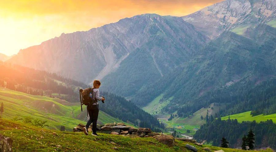
Chembra Peak, Kerala
With soaring peaks of the Himalayas, expansive grasslands, and the humid hills of the Western Ghats, India presents an unparalleled variety of hiking experiences.
Whether you prefer a quick trek in the hills or a grand journey across the high Himalayan passes, there's a perfect trail waiting for you. Many shorter hikes can be tackled independently, including significant pilgrimage routes. For challenging high-altitude treks, local guides are readily available in popular trail areas.
From leisurely day hikes to extended adventures, here’s our selection of the finest hikes in India.
Top Hike in the Western Ghats
7km (4.3 miles) round trip, 5 hours, easy to moderate
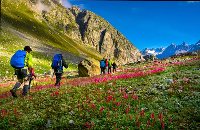
Situated 90km northeast of Kozhikode, Chembra Peak rises to 2,100m (6,890ft), making it the highest peak in Kerala and an easily accessible day hike. The well-marked trail meanders through dense forests, rolling tea plantations, and aromatic coffee and spice estates, rich with the scents of pepper and cardamom. About halfway, you'll encounter a heart-shaped lake, but push on to the summit for breathtaking views of the verdant Western Ghats.
This mountainous area is a biodiversity hotspot, home to over 300 threatened plant and animal species. Hikers should look out for unique wildflowers and, with luck, glimpses of wild Asian elephants, lion-tailed macaques, Malabar hornbills, or Nilgiri tahr (a sheep-like wild ungulate).
The trek to Chembra begins in the quaint village of Meppadi near Kalpetta. An early start is essential since overnight camping is not allowed, and only 200 hiking permits are issued daily. Registration is required at the local forest office in the village; the trail opens at 7am. It's best to avoid this hike during the monsoon season when trails become muddy.
Deoria Tal and Chandrashila Trek, Uttarakhand
Ideal hike for winter landscapes
18–20km (11–12 miles) round trip, 2 days, easy to moderate
Mirroring the snow-draped Himalayan summits in its tranquil waters, Deoria Tal – which translates to 'the bathing place of the gods' – is a stunning lake located about 14km (8.7 miles) east of Ukhimath in the foothills of Uttarakhand, northeast of Delhi. The vistas of 7,138m (23,419ft) Mt Chaukhamba are particularly striking.
Open year-round, the trail to Deoria Tal begins in the charming village of Sari and is straightforward enough to navigate without a guide, making it perfect for independent trekkers. Although it involves a steep ascent, the path is well-maintained and flanked by rhododendron trees that burst into vibrant pink blooms in spring. Camping near the lake is possible, but the hike can also be done as a day trip.
Even better, this can be combined with a trek to the summit of 3,690m (12,110ft) Chandrashila, which looms over Tungnath Mandir. From Sari, it's just 20km (12 miles) to the quaint village of Chopta, the starting point for the pilgrimage to the world's highest Shiva temple. After a 4km (2.5 miles) walk to the temple, you can proceed to Chandrashila's peak for breathtaking 360-degree views of surrounding mountains, including 7,816m (25,643ft) Nanda Devi, India's second-highest peak.
Logistics for the Tungnath hike are simple – numerous small stalls along the route offer basic Indian fare and steaming cups of chai (sweet Indian tea). On your descent, keep an eye out for the vibrant Himalayan Monal pheasant, the state bird of Uttarakhand.
 Treks in Sikkim bring you close to the majestic Khangchendzonga, the third-highest mountain in the world © Flickr Open / Getty Images
Goecha La Trek, Sikkim
Top high-altitude hike for thrill-seekers
91km (57 miles), 10 days, challenging
To tackle the demanding Goecha La hike, you'll need to book through a trekking agency (such as Travel Gangtok Tourism), but for many hikers, this trek is the pinnacle of a journey to the historic Buddhist kingdom of Sikkim. The breathtaking views, which stretch across northeast India and offer spectacular photo opportunities of 8,586m (28,169ft) Khangchendzonga, the third-highest mountain in the world, make the effort worthwhile.
Don't let the trail's humble beginning in the serene village of Yuksom fool you; this area was once Sikkim’s first capital, Rabdentse (with its ruins just outside the village). After an easy start, the path grows more challenging as you ascend. The trek reaches 4,940m (16,207ft) at the Goecha pass, so be sure to acclimatize to minimize the risk of Acute Mountain Sickness.
The trail traverses Khangchendzonga National Park, a revered area for the Lepcha tribe, the original inhabitants of Sikkim, who regard Mt Khangchendzonga as a divine being. As you hike, keep an eye out for Buddhist chortens (stupas), blooming rhododendrons, lush mountain ferns, and natural hot springs. If you're lucky, you might spot red pandas, musk deer, blue sheep, and blood pheasants in the higher elevations.
The optimal times to embark on this hike are in the spring and fall, just before and after the summer monsoon. If you wake up early on day four and take the side hike to Dzongri peak at 4,000m (13,123ft), you'll be greeted with a stunning sunrise over Khangchendzonga.
Triund Trek, Himachal Pradesh
Ideal easy trek for newcomers
11.5 km (7 miles) round trip, 6-7 hours, easy
Perfect for novice hikers, the Triund trek follows a well-trodden shepherd's path that remains accessible year-round. The journey begins at Galu temple in Dharamkot, a favorite spot for backpackers located just north of McLeod Ganj, the seat of the Tibetan Government-in-Exile. Regular buses run from Dharamshala in the valley up to McLeod Ganj.
You can begin this hike from either Dharamkot or McLeod Ganj. The charming trail ascends through a blend of deodar, pine, rhododendron, and oak forests, offering breathtaking views of the valley. The sunset from the ridge at Triund, which sits at 2,850m (9,350ft), is particularly spectacular, painting the sky with vibrant hues of pink, yellow, and orange.
While many trekkers finish the Triund trek in a single day, there are tents, sleeping bags, and food available at the summit campsite if you wish to linger overnight, stargazing and enjoying the shimmering lights of the Kangra Valley below.
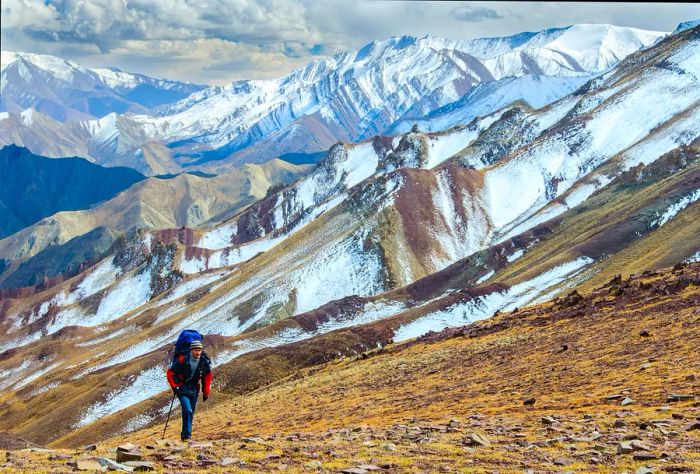 Trekking routes through the high-altitude deserts of Ladakh begin right on the outskirts of Leh © Rosliak Oleksandr / Shutterstock
Markha Valley Trek, Ladakh
Top high-altitude desert trek
65km (40 miles), 6-7 days, moderate to challenging
Winding through the high-altitude deserts of Ladakh, the Markha Valley trek is a popular tea-house trail favored by independent hikers. This trek features overnight stays in cozy village homestays, allowing you to fully engage with Ladakhi culture. It also traverses the stunning Hemis National Park, home to rare Himalayan wildlife like blue sheep, snow leopards, and Tibetan red foxes, along with playful Himalayan marmots.
The journey begins with a brief bus ride from Leh. While the trail can be navigated without a guide, local trekking agencies can facilitate a guided experience with support from porters. The best time to embark on this trek is in July or August when the villages along the route bloom into lush oases, with crops flourishing among the whitewashed homes and ancient Buddhist monasteries.
Hikers must be well-acclimatized, as the trail includes a crossing over a 5,200m (17,060ft) pass. If you’ve flown directly into Leh or traveled quickly from the plains, it's advisable to spend a few days acclimatizing in the Ladakhi capital before starting the trek. While it’s feasible to tackle the route independently, some sections present challenges, including a waist-deep crossing of the Markha River and rocky canyons where careful footing is essential.
This circular trek offers a unique experience each day. Beginning in the village of Chilling and looping southeast to Sumdo, you can include a visit to the breathtaking gompa (Buddhist monastery) at Hemis before returning to Leh. Portions of the Markha Valley can also be explored in winter, providing a better chance to see a snow leopard.
Kashmir Great Lakes Trek, Kashmir
Ideal hike for stunning alpine landscapes
74km (46 miles), 7 days, moderate
Considered one of India’s premier treks, this week-long adventure through the renowned Kashmir Valley showcases seven breathtaking glacial lakes, nestled among wildflower meadows interwoven with crystal-clear streams, all under the watchful gaze of snow-capped peaks. These tranquil lakes, nourished by snowmelt, present an enchanting array of turquoise and aquamarine hues.
As with any journey to Kashmir, it's important to assess the security situation prior to your trip to Srinagar, as occasional unrest may disrupt travel plans. Sharing the trail with goat herders and semi-nomadic sheep, this hike is truly a once-in-a-lifetime experience. Camping is allowed near some of the lakes, and waking up at dawn here offers a breathtaking glimpse into the untouched beauty of the renowned vale of Kashmir.
Beginning at the village of Sitkadi close to Sonamarg, roughly 81km (50 miles) east of Srinagar, this hike is considered moderate by Himalayan standards. The trail culminates at a 4,220m (13,845ft) pass, which you will cross on the fourth day, and showcases stunning and diverse alpine landscapes. Consider joining a small trekking group through a local agency – Indiahikes and Trek the Himalayas can handle all the logistics for you.
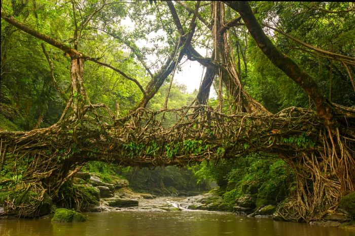 The living root bridges of Meghalaya represent an incredible achievement in engineering © Mazur Travel / Shutterstock
Nongriat Trek, Meghalaya
Best hike to discover Indigenous culture
7km (4.3 miles) round trip, 1 day, moderate
The elevated plateau of Meghalaya is steeped in folklore and legends, featuring hidden valleys, natural pools, and an abundance of waterfalls. However, it’s the living root bridges, crafted over generations by the Khasi villagers in the hills around Nongriat, that draw the most attention. These remarkable structures are created by intertwining tree roots and branches, showcasing an impressive feat of ancient engineering.
The trail to Nongriat begins in the village of Tyrna, located near Cherrapunji, which was once recognized by the Guinness Book of Records as the wettest place on earth. Regular buses run from Shillong, the intriguing capital of Meghalaya, to Cherrapunji. To access the living root bridges, you'll need to descend a steep path comprising over 3,500 stone steps and navigate through lush rainforest filled with butterflies, moths, and other jungle insects.
There are a few basic shops midway along the trail for supplies, but it's advisable to hire a local guide (available in Shillong or Cherrapunji). Be sure to bring a rain jacket, waterproof footwear, and a bag cover, as this region experiences heavy rainfall. It's also possible to spend the night in a homestay in Nongriat, continuing your journey the next morning to the stunning Rainbow Waterfall.
Valley of Flowers Trek, Uttarakhand
Best hike for flower lovers
15–25 km (9–15.5 miles) round trip, 7-10 hours or several days, moderate
Renowned as one of India's top hiking spots, Uttarakhand's Valley of Flowers is celebrated for its stunning variety of vibrant wildflowers that burst into bloom towards the end of the monsoon season within this elevated national park. This protected area is also inhabited by Asiatic black bears, brown bears, and snow leopards, though encountering them is quite uncommon.
Treks commence from the town of Govindghat, located on the route between Joshimath and the sacred Hindu temple at Badrinath. From here, hikers can enjoy an easy 14km (8.7 miles) journey to Ghangaria, where many choose to rest before venturing into the valley itself.
Begin your day early from your guesthouse to arrive at the valley entrance by 7am when the route opens; the last trekkers are allowed entry at noon. Alternatively, you can take the 6km (3.7 mile) path that Sikh pilgrims use to reach Hemkund Sahib, a secluded gurdwara (Sikh temple) nestled beside a breathtaking alpine lake.
 The journey to the Hampta Pass showcases classic Himalayan scenery © muhd fuad abd rahim / Shutterstock
Hampta Pass trek, Himachal Pradesh
Best multi-day hike
21km (13 miles), 5 days, easy-moderate
Once a trail for shepherds and a route for nomadic trade, this inspiring hike leads you from the verdant meadows of Kullu Valley, across the 4,270m (14,009ft) Hampta Pass, to the rugged terrains of Lahaul—an ancient valley steeped in Hindu and Buddhist history that serves as an alternate route to Ladakh.
The starting point for this multi-day adventure is Jobra, just a two-hour drive from the hill station of Manali. You will soon leave the signs of civilization behind as you trek through mixed forests of birch, deodar, and oak, alongside glacial streams and vibrant green meadows blanketed in wildflowers.
The breathtaking vistas of the Lahaul Valley from the pass are unforgettable (don't forget an extra memory card for your camera). Your journey concludes in Chhatru, where a dirt road leads to Chandra Taal (Moon Lake), a picturesque lake situated at an elevation of 4,250m (13,944ft).
Tadiandamol trek, Karnataka
Best trek in South India
12km (7.5 miles) round trip, 7–9 hours, easy
Tadiandamol, the tallest peak in the lush hills of Kodagu—known for its exceptional coffee—offers a perfect day hike for those looking to admire mist-covered greenery swirling with clouds. Beginning at Nalakunad Palace, about three hours from Mysuru, the trail winds through the Brahmagiri Wildlife Sanctuary, a protected area filled with stunted tropical shola forests, stunning grasslands, and babbling streams.
With sweeping views over coffee plantations that also grow spices like pepper, areca nut, and nutmeg, this well-marked trail is a moderate hike that's easy to navigate without a guide. The ideal months for trekking here are from September to March.
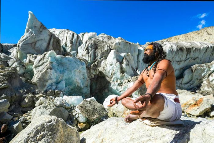 A sadhu (holy man) meditating on a rock at Gaumukh, the sacred source of the River Ganges © Frank Bienewald / LightRocket via Getty Images
Gaumukh Trek, Uttarakhand
Best spiritual hike
36km (22 miles) round trip, 2-3 days, moderate
Following ancient pilgrimage paths, this trek to one of the sources of the River Ganges is among India's oldest hikes. The journey culminates at Gaumukh (meaning Cow’s Mouth), a grand glacier nestled high in the Himalayas, whose meltwater feeds the sacred river. The breathtaking nighttime views of the pointed peak of 6,543m (21,467ft) Mt Shivling, surrounded by countless stars, enhance the trek's enchanting experience.
The trek begins in the pilgrimage town of Gangotri, which is home to one of the revered Char Dham – four of India's most sacred Hindu temples. This moderately challenging hike features a gradual yet steady ascent through increasingly rugged landscapes. Most hikers choose to spend the night at Bhojbasa, located 3km (1.9 miles) before Gaumukh, where tents and a tourist rest house provide basic amenities such as toilets and food stalls.
Khaliya Top, Uttarakhand
Best day hike for Himalayan views
14km (8.7 miles) round trip, (1-2 days), moderate
Perched at 3,600m (11,811ft), Khaliya Top is an alpine meadow that offers stunning 360-degree views of the snow-capped peaks of the Kumaon Himalaya in Uttarakhand. After departing from the Balati Bend forest office, 8km (5 miles) from Munsyari, you'll quickly enter a dense forest filled with rhododendrons and oak trees before ascending to the open hillsides.
The path is clearly marked, featuring steep ascents in certain areas. As you ascend, stunning views of the Panchachuli and Nanda Devi ranges emerge, becoming increasingly breathtaking as you near the KMVN rest house, just before reaching Khaliya Top. Don't forget to pack a lunch to enjoy while you take in the scenery.
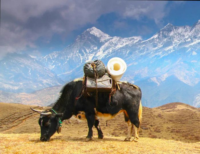 A dzo (a cow-yak hybrid) loaded up and ready for a trek in Sikkim © Sepultura_from_Hell / Getty Images
Hiking tips for India
While hiking is well-established in India, here are some helpful tips for beginners.
When is the best time to hike?
Given India's vast landscape, you can find hiking opportunities year-round. The dry months from October to May are generally suitable, with peak trekking season occurring from March to May in the Himalayan foothills. For the high-altitude valleys of Ladakh, the ideal visiting period is from June to September, when snow melts and access roads from Himachal Pradesh become available.
Regardless of the season, hikers should prepare for all types of weather, as conditions can shift rapidly in the mountains—this variability is being worsened by climate change. Rain patterns have become less predictable, and rising temperatures are leading to the melting of certain glaciers.
Snow typically covers the region from November to March, resulting in challenging trekking conditions. It's advisable to avoid Sikkim, Himachal Pradesh, and the vicinity of Darjeeling during July and August, as heavy monsoon rains can trigger landslides that may wash away roads and trails.
What are the best hiking maps to use?
Thanks to Peter Van Geit, the Belgian founder of the Chennai Trekking Club, high-quality maps of the Indian Himalayas are now accessible. His Ultra Journeys maps are up-to-date and available for free download.
Several useful digital maps can be downloaded for offline use on your smartphone or GPS devices. Gaia GPS and Alltrails offer terrain maps for India, highlighting trekking routes where available. A subscription is required for these services.
Leomann Maps provides excellent coverage for regions such as Kashmir, Ladakh, Uttarakhand, and Himachal Pradesh. Hard copies can be purchased online or at select bookstores. Olizane offers great hiking maps for Ladakh and the Zanskar region, while Indiahikes supplies downloadable GPS files for treks in the Western Ghats.
How to choose a reliable trekking guide?
Investing in a skilled and experienced trekking guide is one of the best decisions you can make during your trip to India. The Indian Mountaineering Foundation in Delhi maintains a list of registered tour operators throughout the country.
Choose a trekking company whose leaders are certified in mountaineering and Wilderness First Aid. It's also important to verify the equipment they provide on their treks—high-altitude routes should always include oxygen cylinders and comprehensive first aid kits.
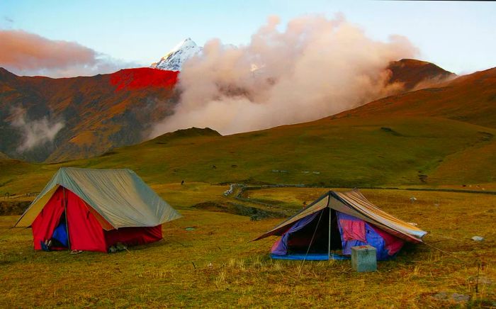 Camping on a Himalayan meadow surrounded by majestic snow-capped peaks is an incredibly moving experience © Priyanka Haldar Photography / Getty Images
How to get ready for trekking in the Himalayas
Pack clothing suitable for rapidly changing mountain weather, including a windproof layer, a down jacket, and a waterproof coat. Break in your hiking boots before starting your trek and invest in a reliable map—many locally available maps may not be accurate for remote areas.
Always bring water (or a water purification method), extra socks, a survival bag, and emergency snacks. Sunscreen, high-UV chapstick, a sunhat, and sunglasses are crucial as altitude increases the risk of sunburn, and snow can be blinding. For multi-day hikes, consider taking your own sleeping bag and roll mat; some trekking companies offer these, but their quality can vary.
Verify if you need any permits for trekking in the Himalayas
Before embarking on your trek, ensure you know whether a permit is required. Special permits are necessary for areas near India's borders, particularly in the northeast. Hikers in Arunachal Pradesh and certain regions of Himachal Pradesh, Ladakh, Sikkim, and Uttarakhand must apply for a General Protected Area Permit.
Permits are typically arranged through local trekking agencies or travel operators, and you'll need to be accompanied by at least one other person to obtain one. Contact agencies in advance to make arrangements. Permits usually last for 10 days with an option to extend for another week. Indian citizens require an Inner Line Permit, which can be obtained from the local state government.
How to adjust to high altitudes for a mountain trek
Avoid starting your trek from high altitudes. Acute Mountain Sickness (AMS) poses a serious threat above 2,500m (8,200ft) and can be life-threatening. On any high-altitude hike, ascend gradually, refrain from alcohol and diuretics, stay hydrated, and incorporate regular rest days to help your body acclimatize as you gain altitude. If you're coming from lower elevations, spend a few days acclimatizing before you set out on your trek.
If you experience any symptoms of AMS during your trek—such as dizziness, fatigue, nausea, increased heart rate, shortness of breath, headaches, or difficulty sleeping—do not ascend further. If symptoms worsen, descend immediately. Aim to sleep at a lower elevation than your highest point for the day, and avoid sleeping at an altitude more than 500m (1,640ft) higher than where you rested the previous night.


Evaluation :
5/5