Google Maps criticized for suggesting ‘potentially deadly’ hiking routes
Mountaineering organizations in Scotland are warning that hikers aiming to summit Ben Nevis and other nearby peaks are being directed towards ‘potentially deadly’ routes by Google Maps.
The John Muir Trust stated on Thursday that increasing numbers of hikers using Google Maps to navigate Ben Nevis risk being led down a route that is 'extremely dangerous, even for seasoned climbers.'
Ben Nevis, the highest mountain in the British Isles at 1,345 meters (4,413 feet), is a popular hiking destination. Although thousands attempt to summit it each year, the climb is perilous, with fatalities recorded as recently as this year.
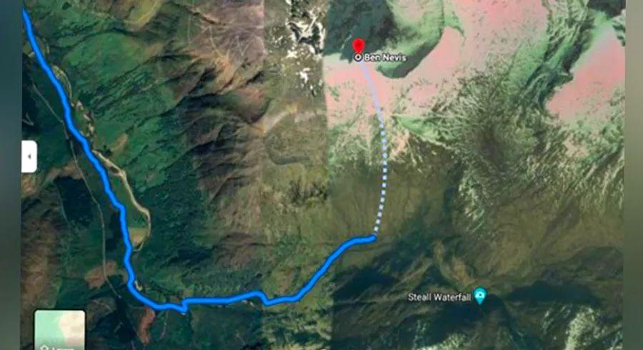
Nathan Berrie, Nevis Conservation Officer for the John Muir Trust, explained in a statement, “The issue arises when Google Maps directs visitors to the Upper Falls car park, likely because it is the closest to the summit.”
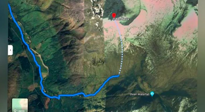
Berrie explained, “This is NOT the correct route, yet we frequently encounter inexperienced hikers heading towards Steall Falls or the southern slopes of Ben Nevis, mistakenly believing it’s the path to the summit.”
Mountaineering Scotland has also issued a warning about a route suggested by Google Maps, calling it 'potentially deadly.'
Heather Morning, Mountaineering Scotland’s mountain safety advisor, explained in a statement, “For those new to hill walking, it might seem perfectly reasonable to turn to Google Maps for guidance on how to reach your chosen mountain.”
“But when you search for Ben Nevis and click on the ‘car’ icon, a route map appears, leading you to the car park at the head of Glen Nevis, with a dotted line seemingly pointing to the summit.”
Morning pointed out that “even the most seasoned mountaineer would struggle to follow this route. The path goes through steep, rocky, and unmarked terrain, where even on clear days, finding a safe route would be difficult. Add poor visibility from low clouds and rain, and the suggested Google route could be deadly.”
Over a cliff
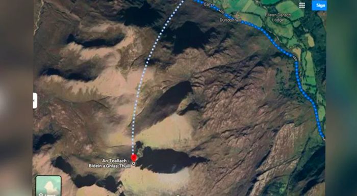
She also mentioned that Google Maps suggested alternate routes that would lead users into 'life-threatening terrain' when trying to navigate other high peaks in the country, including the 1,062-meter An Teallach.
For An Teallach in the northwest, she explained that when a ‘walking’ route was searched, Google Maps proposed a path that would lead hikers directly over a cliff.
“It’s easy to assume that information found online is reliable, accurate, and safe. Unfortunately, experience proves otherwise, with several recent incidents where following online routes has resulted in injury or even death,” she explained.
Mountaineering Scotland said they are hoping to work with Google to remove any 'life-threatening' routes, adding that John Muir’s previous appeals to Google have gone unanswered.
A Google spokesperson told Dinogo that the company is currently investigating the complaints.
“We designed Google Maps with a focus on safety and accuracy, and we are moving swiftly to investigate the routing issue on Ben Nevis and nearby areas,” the spokesperson wrote in an email.
“Along with using reliable data and high-definition imagery to update our maps, we encourage local organizations to share geographic details about roads and routes via our Geo Data Upload tool,” the spokesperson added.

1

2
3

4
5
Evaluation :
5/5