Top 5 Districts to Explore in San Francisco

As the heart of the Bay Area, San Francisco attracts millions of visitors annually, and it’s easy to see why. This cultural hub of Northern California is celebrated for its stunning landscapes and rich cultural tapestry, making it one of the most exciting and sought-after cities in the U.S. and beyond.
Each neighborhood in San Francisco boasts its own unique culture. If you're planning a trip, be sure to check out these highly recommended districts and find out how to get there!
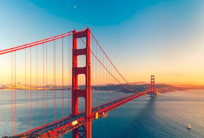
1. Golden Gate Bridge
 Image credit: unsplash
Trendy neighborhoods such as the Marina District, Cow Hollow, and Pacific Heights offer breathtaking views and historic sites, including Fort Mason, The Presidio, and the famous Golden Gate Bridge.
For those who love to stroll, hop on the Historic F-line streetcar from downtown along the Embarcadero to Fisherman's Wharf, then walk along the Bay past Fort Mason—there's a slight incline—towards the Marina Green. If you're in the downtown area, just follow Van Ness Ave north and turn left between California St and Lombard St.
2. Fisherman's Wharf
 Image credit: unsplash
A bustling waterfront area featuring Ghirardelli Square, Pier 39, and the ferry terminal to Alcatraz Island, along with numerous seafood eateries and souvenir shops.
Given its close proximity to downtown, one of the easiest ways to reach the Wharf is by walking! Head east through Fort Mason from the Marina (about 15 minutes), go north along Columbus Ave from North Beach and Chinatown (around 25 minutes), or stroll north from either the Ferry Building or the Financial District along the Embarcadero promenades (approximately 25 minutes).
3. Nob Hill & Russian Hill
 Image credit: unsplash
Perched on the hills with stunning views of the bay and the vibrant downtown San Francisco, these two neighboring areas are renowned for their affluence, breathtaking vistas, and the historic cable cars that still navigate the steep streets.
All three Cable Car lines intersect at Powell and California. The Powell-Hyde and Powell-Mason lines connect Union Square to Fisherman's Wharf. The Powell-Hyde line travels along Powell Street, Jackson/Washington Streets, and Hyde Street, climbing Nob and Russian Hills while stopping at the top of Lombard Street’s famous crooked section. The Powell-Mason line operates along Powell and Mason Streets on the eastern edge of the district. The California line runs east-west on California Street from Market Street in the Financial District to Van Ness Avenue.
4. Chinatown-North Beach
 Image credit: unsplash
Home to two lively immigrant communities, this area features the bustling and largest Chinatown outside of Asia alongside the stylishly relaxed 'Little Italy,' as well as Telegraph Hill and Coit Tower.
All three Cable Car lines travel through Chinatown. If you arrive via BART or the MUNI Metro at the Powell St. Station, you can board the Powell-Mason or Powell-Hyde cable cars at Powell and Market. Both lines will take you into Chinatown, but the Powell-Mason line is more direct for reaching North Beach, while the Powell-Hyde line veers west at Jackson, heading into Russian Hill. To access Chinatown's famous Grant Avenue via cable car, disembark at the Embarcadero Station and catch the California line at California and Market.
5. The Avenue
 Image credit: unsplash
Golden Gate Park, the misty Sunset, the hilly Richmond district, and the rugged cliffs of Lands End form the Avenues of western San Francisco. Primarily residential, this area is home to one of the city's most ethnically diverse populations, featuring San Francisco's main beach, delightful shops and eateries, stunning coastal views, and the expansive Golden Gate Park, which boasts numerous gardens, lakes, meadows, and forests. The region is bordered by the Pacific Ocean to the west, Lake Street to the north, Arguello Blvd and Stanyan Street (from Lake to Frederick Street), and 7th Avenue (from Lincoln to around Golden Gate Heights Park, or about Quintara) and 19th Avenue (from Quintara to Sloat) to the east, with Sloat Blvd marking the southern boundary.
Geary Boulevard serves as the primary east-west route through Richmond. The 38-Geary and 38R-Geary Rapid buses offer frequent service from downtown via Union Square. Although the district is only eight blocks long from north to south, there are parallel bus lines, including 1-California and 2-Clement north of Geary, and 31-Balboa, 5-Fulton, and 5R-Fulton Rapid south of Geary Boulevard.
Wikivoyage
1

2

3

4

5
Evaluation :
5/5