Vermont’s top 7 hiking trails

Filled with hardwood forests that burst into a spectrum of colors during spring and autumn, adorned with wildflowers and carpeted with fallen leaves, Vermont is a hiker's haven.
Dive into lakes, ponds, or waterfalls for a refreshing dip, and you're never too far from town when your hike concludes. Vermont sparked the locavore movement and boasts the highest number of artisan cheesemakers per capita in the US, along with a thriving microbrewery and microdistillery culture. In short, there's always a delicious reward waiting for you after your adventure.
 The Long Trail becomes increasingly challenging as it ascends northward toward Mt. Mansfield © Brothers Welch / Shutterstock
1. The Long Trail
Top thru-hike 272 miles (438km), 5-28 days, ranging from easy to challenging
The Long Trail, the first of its kind, is the oldest continuous footpath in the United States and served as the model for the Appalachian Trail. It winds along the backbone of the Green Mountains, passing through northern hardwood forests and alpine tundra, crossing mountain streams and brooks, and stretching from Massachusetts to Canada.
Finish the complete end-to-end hike for ultimate bragging rights. However, many opt for day trips, tackling it over the years by spending weekends or even afternoons on the trail. Over 166 miles of side trails lead to the Long Trail and its 70 backcountry campsites.
In southern Vermont, the Long Trail and the Appalachian Trail run parallel for 100 miles. The trail becomes increasingly rugged as it ascends toward Mt. Mansfield and Jay Peak, with some steep sections in the north featuring permanent ladders to aid hikers in navigating steep rock faces.
Each season on the Long Trail presents its own beauty and challenges. Spring flowers may be accompanied by rain, leading to muddy or snowy peaks; hot summer days can bring crowds, humidity, and bugs. Fall offers unpredictable weather, yet the vibrant colors of autumn leaves are unparalleled. Winter transforms the trail into a stunning, otherworldly landscape, demanding the right gear and navigation skills.
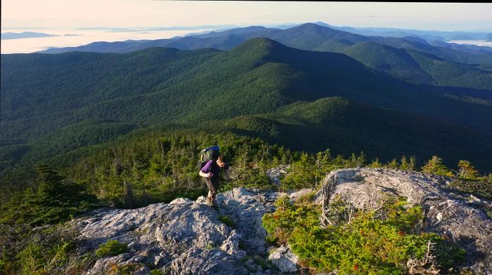
 The Green Mountains of Vermont provide breathtaking panoramic vistas of the surrounding area © OGphoto / Getty Images
2. Mt Hunger
Best hike for vistas of Mt Mansfield 4.2 miles (6.8km), 3 hours, challenging
To capture views of Mt. Mansfield, Vermont's tallest peak, embark on a hike up 3,538 ft Mt. Hunger. The trailhead is approximately 45 minutes from Burlington, Vermont’s largest city, and about 15 minutes from Stowe.
The first mile is gentle, but this out-and-back hike steadily ascends 2,263 ft to the summit. Though it’s challenging, the effort is rewarded with sweeping views of the Green Mountain State. Along the way, you’ll navigate rocky stairs, pass under moss-covered waterfalls, splash in a swimming hole, and finally reach Mt. Hunger’s rocky peak, offering 360-degree views of New Hampshire’s Presidential Range to the east and the Green Mountains stretching to the north, south, and west.
The final mile is the steepest, but hikers unanimously agree that the bird's-eye perspective of northern New England makes it all worthwhile.
 The ascent to Mt. Philo offers expansive views of Champlain Valley and Lake Champlain © Robert Nickelsberg / Getty Images
3. Mt Philo
Best hike for hawk watching 1.4-1.9 miles (2.25-3km), 1-1.5 hours, moderate
Champlain Valley, renowned for Lake Champlain, is often referred to as Vermont’s breadbasket due to its fertile soils and rich agricultural land. The hike up Mt. Philo offers expansive views of the Valley, Lake Champlain, and New York’s vast Adirondack Park. Standing at 968 ft, Mt. Philo is a prominent feature within Vermont's 232-acre Mt. Philo State Park in Charlotte (pronounced Shar-lot).
In the 1930s, the Civilian Conservation Corps (CCC) undertook efforts to plant trees and construct roads, trails, a campground, ranger quarters, a picnic area, and a summit lodge at this scenic lookout.
Some hikers prefer the paved road to reach the summit, while others enjoy the natural trails along the way. Both the paved route and the park’s trails provide access to beautiful hardwood forests, views of Mt. Philo’s mid-mountain cliffs, and a summit vantage point to appreciate the landscape.
This is one of the prime spots for hawk watching in Vermont, especially towards the end of September. Mt. Philo holds the state record for the highest number of migrating raptors observed in a single day – 3,688. You can reserve one of the park’s 10 campsites and drive up the access road, or park at the base and pay a fee at the entrance for day use.
 Grout Pond is a fantastic spot for swimming, fishing, or paddling © trsers / Shutterstock
4. Grout Pond Trail
Best hike for recreational activities 2.7 miles (4.3 km), 1-1.5 hours, easy
Gaining altitude isn't the only measure of a great hike. As you circle the 80-acre Grout Pond, you’ll only ascend 249 ft, yet you’ll encounter loons, kayakers, wildflowers, mushrooms, and mosses, all while immersed in the beauty of the Green Mountains.
Nestled within the 1,600-acre Grout Pond Recreation Area, Grout Pond is a fantastic spot for swimming, fishing, or paddling. The recreation area features 10 miles of multi-use, non-motorized trails that link to the Somerset Reservoir trail system, which transforms into Vermont’s end-to-end ski trail, the Catamount, during winter. The lower trails can be soggy, so there are boardwalks in certain sections. Additional activities include camping, canoeing, kayaking, and fishing for a varied experience.
 Peak activity on the Sunset Ridge Trail’s bustling hiker highway © Andy Shih / Shutterstock
5. Mt Mansfield via Sunset Ridge
Top hike for elevation gain 5.9 miles (9.5km), hours, challenging
When visiting Vermont for hiking, don’t miss the chance to conquer Mt. Mansfield. At 4,395 ft, it is the highest peak in Vermont, towering over Stowe to the east and Underhill to the west. It’s one of three rocky summits in Vermont where remnants of Ice Age alpine tundra still exist.
Legend has it that the mountain was named for its profile, resembling the forehead, nose, lips, chin, and Adam's apple of a reclining man, with the summit representing the chin. There’s also a tale of a mythical deer/wild boar creature that roams the slopes, known as the Wampahoofus, said to have mismatched legs from traversing Mansfield's steep terrain.
Multiple routes lead to the summit of Mt. Mansfield. You can start from Underhill and hike the open rock path known as Sunset Ridge, or choose one of the more difficult trails that run alongside it for stunning views. Adventurers seeking a challenge might attempt Hell Brook from the Smuggler’s Notch side. For a gentler approach, you can drive the 4.5-mile winding Toll Road near the mountain’s ‘forehead’ and trek to its ‘chin’ (or as far as your legs, the weather, and your ambitions allow).
6. Mt Abe from Lincoln Gap
Best hike for expansive views 5.1 miles (8.2km), 4 hours, challenging
Mt. Abraham, affectionately known as “Mt. Abe” by locals, might be named after President Abraham Lincoln, or possibly Revolutionary War hero Benjamin Lincoln, similar to the nearby Lincoln Peak. Situated in Lincoln, Vermont, the peak is also referred to as Potato Hill and Lincoln Mountain, among other names.
Regardless of its name, the 4,006 ft peak is Vermont’s fifth highest, and the journey to its alpine-tundra adorned summit ridge is both stunning and demanding. The most frequented trail to the top follows Vermont’s Long Trail, beginning at Lincoln Gap.
The trail winds along a rocky path until reaching a lean-to-style shelter equipped with a picnic table and privy. From there, it’s a vigorous scramble to the summit, which offers one of the finest views along the Long Trail. On a clear day, hikers can spot New York’s highest peak, Mt. Marcy to the west, the slopes of Killington Resort to the south, and, 80 miles to the east, Mt. Washington commanding the skyline of New Hampshire’s Presidential Range.
 Glaciers sculpted the distinctive shape of Lake Willoughby and raised the peaks on either side © Denis Tangney Jr. / Getty Images
7. South Trail, Mt Pisgah
Best hike for mountain lakes and nesting falcons 4.1 miles (6.6 km), 2.75 hours, moderate
Situated in Vermont’s Northeast Kingdom, Lake Willoughby ranks among the state’s coldest and deepest bodies of water. Glaciers carved out the lake’s form, creating towering peaks on either side. Mt. Pisgah stands tall on the east side of Willoughby Gap, while its neighboring peak, Mt. Hor, looms over the lake’s western side.
Begin your adventure on the South Trail, hiking a mile to Pulpit Rock, a nesting site for peregrine falcons and one of the finest viewpoints of Lake Willoughby. Some hikers choose to turn back here for the view, while others opt for the side trail leading to a rocky ledge that seems to hover 650 ft above the lake.
Proceeding onward, the path becomes a moderate-to-challenging dirt trail leading to the summit ridge, offering expansive views of northern Vermont and southern Canada as the ridge curves eastward away from the lake.
Evaluation :
5/5


