Explore Brazil's best road trips, leading you through mountains, jungles, and breathtaking beaches.

Hitting the road in Brazil opens up a realm of adventure. Although the distances can be vast and some routes challenging, the joy of navigating the country's winding coastal paths, inland highways, and majestic mountain roads will leave a lasting impression.
Driving in Brazil can be tricky due to the opt-in nature of traffic laws and the fact that 87% of the country’s highways are unpaved and undivided. However, if you focus on daytime travel and steer clear of major cities, you'll find road trips much more enjoyable.
With thoughtful planning and a commitment to a leisurely pace, a road trip through Brazil can transform into an exhilarating journey through stunning natural landscapes. Here’s your guide to the finest road trips in Brazil.
YouTube video playback
Rio-Santos Highway
The ultimate road trip for stunning beaches
Santos–Rio de Janeiro; 550km (341 miles)
While the coastal route between Rio de Janeiro and São Paulo isn’t the fastest way to travel, it’s undeniably the most captivating.
Nestled between the lush slopes of the Serra do Mar and the Atlantic Ocean, this winding road showcases the coastline's beauty, meandering past countless beaches and numerous islands, with spots like Ilha Grande and Ilha Bela perfect for an overnight stay during your journey.
Though you can complete the trip in two to three days, savoring the journey is highly recommended. Built in the 1970s, this route offers stunning ocean views throughout, meandering past glimmering rivers, tranquil fishing villages, and lively tourist areas.
The Portuguese-established town of Paraty is a must-visit for an overnight stay, along with the stunning beaches north of Ubatuba, such as Praia do Félix and Itamambuca.
Make sure to carve out time for activities. Along the route, you can discover waterfalls, hike through the lush Atlantic Forest, and sample cachaça at local distilleries. Don’t forget to stop at beach shacks or fine dining spots to experience caiçara cuisine, a seafood-rich culinary tradition from Brazil’s southeastern coastal communities.
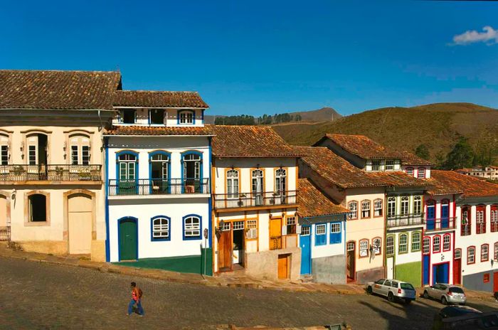
 Ouro Preto is famed for its steep, cobbled streets © Danny Lehman / Getty Images
The Royal Route
The ultimate road trip for exploring historical landmarks
Ouro Preto–Paraty; 710km (441 miles)
The Estrada Real (Royal Road) represents a significant part of Brazil’s colonial past along its 932-mile path. More than just one road, it’s a network established by the labor of countless enslaved individuals from the 17th century, connecting mining towns in the interior with ports in Paraty and later Rio de Janeiro, where gold and diamonds were shipped to Portugal. It’s a classic colonial narrative.
Today, this route is celebrated for its breathtaking landscapes, rich culture, and historic architecture, linking many of Brazil's most beautiful colonial towns. To assist travelers, the Instituto Estrada Real offers maps and a Royal Road “passport” that can be stamped at various checkpoints along the journey.
The most captivating segment is the Caminho Velho (Old Route), connecting the colonial towns of Ouro Preto, Tiradentes, Mariana, and Congonhas, renowned for their baroque churches and steep cobbled streets.
Driving the Caminho Velho takes approximately eight days, primarily along unpaved roads, so a 4x4 vehicle is essential. The journey begins in Ouro Preto and concludes on the coast in Paraty—both recognized as UNESCO World Heritage sites for their historical and ecological significance.
Take time to explore along the way, visiting waterfalls, local cheesemakers, and eateries offering comida mineira (hearty comfort food from the region, featuring corn, cassava, beans, and pork, traditionally cooked over wood-fired stoves). Trips can be coordinated with the various festivals along the route, celebrating everything from film to photography to cuisine.
 Salvador is a lively center for Afro-Brazilian culture © Peter Adams / Getty Images
The Northern Bahian Shore
The ideal road trip for stunning ocean views
Aracajú–Boipeba; 560km (347 miles)
Bahia boasts the longest coastline of any Brazilian state, stretching an impressive 930km (579 miles) and featuring a blend of upscale beach resorts, quaint fishing villages, and everything in between. Sections of this coastline are affectionately named Coconut Coast, Cacau Coast, and the Discovery Coast, among others.
In Bahia, the pace of life is relaxed, and embracing this mindset is key to enjoying the road trip. Make frequent stops for fresh seafood lunches and refreshing swims in the ocean.
Beginning in the capital of Sergipe, Aracajú, it's a straightforward drive south to Mangue Seco, a stunning peninsula at the northern edge of Bahia and the gateway to the palm-lined Coconut Coast. Don't miss the vacation hotspot of Praia do Forte and the Tamar turtle conservation project before arriving in Salvador, the historic capital and cultural center of Brazil’s Afro-Brazilian heritage.
A regular car ferry traverses the Bay of All Saints to Bom Despacho, where the Dendê Coast continues southward, featuring even more inviting beach stops. To conclude your journey, park in Valença or Graciosa and take a quick speedboat ride to Boipeba Island, renowned for its untouched white sands and crystal-clear waters.
 Freshwater lagoons emerge during the rainy season within the dunes of Lençóis Maranhenses National Park © Luiz Felipe Sahd / Getty Images
Rota das Emoções
The ultimate road trip for a getaway
São Luís do Maranhão–Jericoacoara; 642km (399 miles)
A more poetic interpretation of Rota das Emoções might be a ride on the wild side—the 'Route of Emotions' (we hope they’re joyful). This extensive road connects São Luís, the capital of Maranhão, with the beach getaway of Jericoacoara, showcasing the natural wonders of this wind-swept region along Brazil’s northeastern coast.
Your first destination is Lençóis Maranhenses, where stunning freshwater lagoons emerge during the rainy season across a 1550 sq km (598 sq mile) area of sand dunes. For the best views of Lençóis Maranhenses National Park, consider a chartered flight, though hiking, quad biking, and jeep tours offer the added delight of swimming in the lagoons.
Next, visit the Parnaíba River Delta, a network of islands rich with mangrove forests and diverse flora and fauna best discovered by boat. Watch as vibrant red guarás (scarlet ibises) fill the sky at sunset, returning to roost.
The last leg of the journey winds along the Ceará coast—one of the premier kitesurfing destinations in the world—culminating in Jericoacoara (or “Jeri”). Here, you can spend a few days enjoying the stunning national park, kitesurfing, or simply relaxing on the beach. The town is enveloped by sand dunes and the sea, but you can reach Jeri by hiring a local guide in Jijoca or Prea and lowering your tire pressure to tackle the sandy roads on the final stretch.
Alternatively, you can park outside the dunes and take a 4x4 transfer. The charming town of Camocim also offers parking options and beach buggy rides to Jeri.
 The jaguar is the elusive animal that everyone hopes to encounter in the Pantanal © dickysingh / Getty Images
Estrada Transpantaneira
The ultimate road trip for wildlife enthusiasts
Poconé–Porto Jofre; 150km (93 miles)
The Pantanal is the largest wetland on the planet, spanning approximately 209,790 sq km (81,000 sq miles), primarily in Brazil, with portions extending into Bolivia and Paraguay.
This natural paradise is a must-see for wildlife lovers, brimming with large creatures like caimans, capybaras, and jaguars, as well as a diverse array of birds. While more remote areas of the Pantanal are best accessed by plane or boat, you can also reach it via the Transpantaneira road – route MT-060.
This unpaved road enters the Pantanal from the north and is drivable in a standard car during the dry season (April to September), when wildlife sightings are more frequent. However, a 4x4 is necessary during the rainy season when rivers can transform into lakes. Along the Transpantaneira, you'll find a range of hotels that can organize boat trips and nighttime excursions to spot wildlife.
Following the devastating fires in the Pantanal in 2020, a campaign was initiated to attract tourists, advocating for responsible tourism as a sustainable economic alternative to cattle ranching, aimed at preserving the region's unique biodiversity. The Instituto Homem Pantaneiro is a local NGO that promotes ecotourism experiences and reinvests its earnings into local conservation efforts.
 Ascending Pico da Bandeira is a must-do during your visit to Espírito Santo province © André Dib / Getty Images
Espírito Santo Mountains
The ultimate road trip for food and drink enthusiasts
Start – Vitória; End – Alto do Caparaó; Distance – 151 miles/243km
The coastal state of Espírito Santo lies between Rio de Janeiro and Bahia, and its lush mountains boast some of Brazil's finest hiking trails. Less than an hour's drive from the state capital, Vitoria, the BR-262 highway gradually ascends into the Serra Capixaba, where an agritourism movement has thrived in recent years.
Organic farms, gourmet shops, eateries, cafes, and guesthouses are all part of a scenic route connecting Domingos Martins and Venda Nova do Imigrante.
In the mid-1800s, immigrants from Germany, Italy, and Pomerania (a historical region on the Baltic Sea) settled in this area, living in relative seclusion until the BR-262 was built in the 1960s.
Many of their culinary traditions endure, especially in their kitchens. In Venda Nova do Imigrante, standout dishes include socol (an Italian-style pork sausage) and polenta; the town even hosts an annual polenta festival featuring a massive pot of polenta that weighs over a ton.
The Rota do Lagarto is a picturesque 8km (5-mile) detour from the BR-262, leading to the entrance of Pedra Azul State Park, where hikers can ascend the iconic “blue” granite rock that names the park. For breathtaking views and a more strenuous hike, continue an additional 62 miles to Pico da Bandeira, which stands at 2892m (9488ft) as Brazil's third-highest peak.
 The road that winds around Serra do Rio do Rastro may be the most stunning drive in Brazil © Micael Bergamaschi / Getty Images
Rio do Rastro
The ultimate road trip for breathtaking panoramas
Lauro Muller–Bom Jardim da Serra; 34km (21 miles)
High in the Serra Catarinense, where winter dusts the peaks with snow, the Rio do Rastro road elegantly twists along a sheer ridge, featuring a series of sharp turns. This brief yet dramatic stretch of road, clinging to the steep mountainside, might just be Brazil's most stunning drive.
Along the route, spectacular views of the valleys unfold, with panoramic lookout points inviting drivers to stop for photos. You can start or end your journey in either Lauro Muller or Bom Jardim da Serra, the two quaint towns flanking the Rio do Rastro road, officially known as the SC-390, which concludes about 100km (62 miles) east at the coast.
At the road’s peak, the 1460m (4790ft) Mirante Serra do Rio do Rastro offers a perfect spot for a lunch break. On clear days, the view extends to the Atlantic Ocean; to avoid morning fog, plan your visit between 11am and 3pm.
From this viewpoint, a quick 2.9km (1.8-mile) detour leads to the Cânion da Ronda, a canyon boasting a 360-degree view, a wind farm, and a rewarding short hiking trail. While in the vicinity, don’t miss a visit to the Barrinha waterfall.

1

2

3

4

5
Evaluation :
5/5