I Hiked Across an Entire European Nation in Just Three Days
Upon arriving in Liechtenstein, the petite Alpine principality nestled between Switzerland and Austria, the first lesson I learned was my mispronunciation of its name. It’s not the harsh, Germanic sound of 'Ach!'—even though German is the official language. Nor is it the smooth Swiss 'chalet' heard at Zurich airport. Instead, it's a more subtle pronunciation: the soft, aspirated 'chutzpah.' Think 'Leechhh-ten-shtein.'
The second revelation came when I realized that the sunscreen I had prudently purchased for my three-day trek along the Liechtenstein Trail—stretching 47 miles from the Swiss border in the southwest to the Austrian border in the northeast, crossing all 11 municipalities—would be nearly useless: it was going to rain heavily every single day. Exhausted hikers from Philadelphia I met in Vaduz, the capital, warned me that the wet conditions made their hike far more strenuous than they anticipated and cautioned about the treacherous, muddy slopes ahead.
However, on the first day of my trek, descents weren't my concern. The initial seven miles of the trail, starting just outside Balzers, were relatively flat. As I hoisted my day pack and stepped out into the light drizzle, I felt confident I could handle the challenge. Yes, I was 53 and hadn’t hiked more than three or four miles at a time in decades. And yes, through the thick fog, I could barely make out that night’s destination: the village of Triesenberg, perched about 1,500 feet up what appeared to be a sheer ridge. But I refused to let a little rain hinder an adventure I had long envisioned. More importantly, my suitcase awaited me in Triesenberg, so I had to ascend the ridge one way or another.
My passion for solo travel didn’t begin on the best note. At 19, I was fortunate enough to spend a summer studying in Paris. On my very first night, a lodging mix-up left me in a budget hotel somewhere on the Left Bank. Despite my excitement for my inaugural trip to Europe, I found myself crying myself to sleep. It wasn’t homesickness or loneliness, but rather a profound sense of existential solitude—a sudden awareness of how vast the world is and how minuscule my role in it.
Throughout my 20s, I sought out destinations untouched by anyone I knew, exhausting my limited savings on solo adventures in Belize, Mexico, India, Nepal, and Bolivia. At 28, I sold off all my possessions and relocated to Cusco, Peru, where I spent nearly two years. I learned to welcome that initial jolt of solitude, that sensation of floating in the void, unmoored from everything familiar. I relished the gradual process of acclimatization, the satisfaction that came from navigating new environments, until one day I woke up and realized I no longer felt adrift. By the time I returned to the U.S., I was convinced there was no corner of the globe I couldn’t explore alone. But my 30s ushered in a full-time teaching position, my 40s brought marriage, fatherhood, and homeownership. The days of abandoning everything to catch the next flight felt like a distant memory.
So, when I discovered the Liechtenstein Trail, launched in 2019 to commemorate the country’s tricentennial, I became captivated. There was something almost mythical about Liechtenstein, the sixth smallest nation globally, covering just over 60 square miles with a population of 39,000—similar to that of my university. I imagined myself boarding a Swiss bus to the border, hiking over snowy mountain ridges, sharing schnapps with tall, hearty Liechtensteiners. The catch? The self I envisioned was 20 years younger. Did I still possess the stamina?
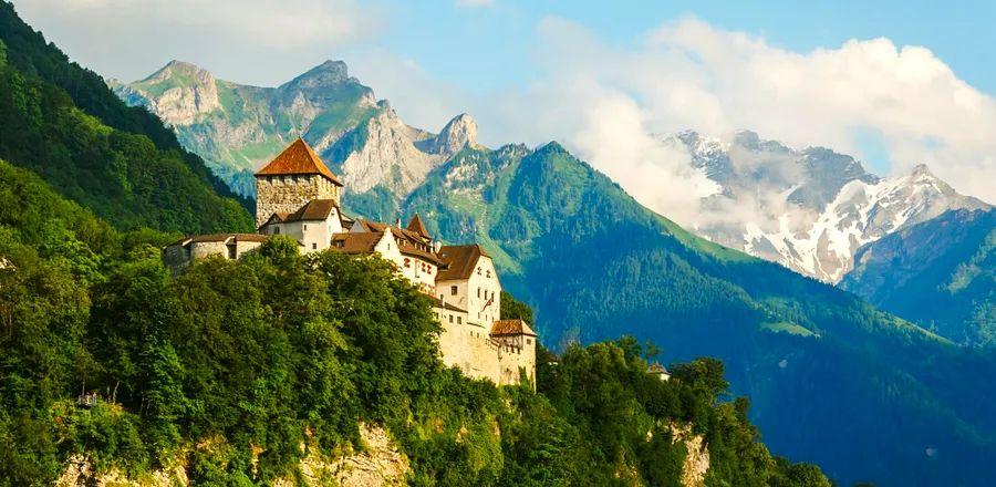
Balzers lies across the Rhine from the Swiss town of Sargans. Its most prominent feature is the 13th-century Gutenberg Castle, rising 200 feet above the pasture like a white monolith, visible from Vaduz five miles to the north in clearer weather. From the trailhead, I strode briskly along the Swiss–Liechtenstein border, pausing occasionally to check my route on LIstory, an app created for hikers on the Liechtenstein Trail that highlights 147 'points of interest,' offering a history lesson of central Europe from the Middle Ages to present. I reached Gutenberg Castle in under an hour and took a moment to rest within the bailey, surrounded by steep mountains pushing through low-hanging clouds.
The castle, which belonged to the Habsburgs for centuries before falling into disrepair in the 18th century, requires prior appointments for entry—no problem, I thought, as LIstory offers an augmented reality tour of the interior. However, LIstory can’t guarantee a reliable cell signal, and the app only 'unlocks' points of interest when it detects a hiker’s presence. For 10 frustrating minutes, I wandered around the castle, standing on benches and waving my phone toward the sky, futilely trying to connect. When a fresh drizzle rolled in, I gave up, consumed an energy bar, and continued on my soggy journey. (The latest version of LIstory allows hikers to manually unlock points of interest.)
The rest of the morning turned into a leisurely stroll rather than a strenuous hike, the brisk weather urging me past a 9th-century grain mill and a woodland shrine dedicated to 200 accused witches executed in the 17th century. Just outside Triesen, I paused for lunch amidst the wildflower-dotted landscape of the Matilaberg nature preserve, where I half-expected Julie Andrews to twirl over the nearest hilltop. I was making good time, but I sensed a steep climb approaching; Triesenberg was now obscured by thick clouds. The further I ventured from the river, the more isolated my surroundings appeared. An elderly man with hiking poles shuffled past and greeted me in German—the first human interaction since I disembarked from the bus in Vaduz that morning. The app indicated I had about a two-hour ascent ahead—but it seemed the app no longer accurately tracked my location.
The climb truly commenced at the St. Mamertus Chapel, a modest, unadorned church featuring frescoes from the 14th or 15th century. Intense rain began about ten minutes later.
Soon, the paved roads and small vineyards transformed into gravel paths that meandered through steep hillside pastures. The lush Rhine Valley, inviting beneath a thick layer of clouds, suddenly felt far beneath me. After pausing to don my flimsy rain jacket, I plunged into the woods, urging my legs and lungs to propel me up the narrowing, muddy trail, where protruding tree roots offered grip on the sharp turns.
Forty grueling minutes later, I broke through the trees and encountered a dozen curious llamas, part of a herd maintained by local farmers who host treks and fondue events. By this time, I was drenched and shivering, but the app—now cheerfully showcasing my little red dot—indicated I had just over a mile left to go.
Just before 5 p.m., I squished my way into Triesenberg, a town of 2,600 residents. After quickly changing into dry clothes, I settled down for dinner on a covered terrace, watching the sun dip below the drenched valley. Then I lay in my narrow hotel bed, congratulating myself for completing the first day, while checking the weather forecast—more rain. The town outside was eerily quiet. As I drifted into sleep, I pondered how few people in the world even knew where I was. I found comfort in being alone in one of the most isolated places I’d ever visited.
Part of the charm of the trail is that you might encounter more cows than people.
“Liechtenstein isn’t a destination for mass tourism and likely never will be. It simply wouldn’t fit the trail concept,” said Nicole Thöny, a project manager at Liechtenstein Marketing, the predominantly government-funded organization that created the Liechtenstein Trail. In 2017, in preparation for the tricentennial celebration, her team began plotting a route that would connect segments of Liechtenstein’s 400 kilometers of hiking trails, highlighting the nation’s beauty and culture. The initial vision was for a marathon-length path: 42 kilometers. However, local officials and historians had other suggestions, Thöny explained. “They insisted that the trail must pass by this church and this mountain. Ultimately, it expanded to 75 kilometers.”
The initiative to attract tourists to Liechtenstein proved to be insightful as the pandemic unfolded. The trail had been open for less than a year, yet it quickly became evident that for locals and visitors from Switzerland and Germany, it was one of the few remaining options for outdoor recreation. For local hotels and restaurants, it ensured a steady stream of business. By the summer of 2020, tourism had noticeably recovered. Three years later, according to Martin Knöpfler, who oversaw the trail's design, hotel occupancy rates are now 30 percent higher than they were prior to the trail’s inauguration.
Since the trail is free and does not require registration, it’s impossible to gauge how many people have hiked it. (Liechtenstein Marketing offers travel packages that include accommodations, meals, and luggage transfers, but these account for only a small fraction of those undertaking the trek.) In Vaduz, the tourist center maintains a logbook for hikers to sign after completing the trail; my friends from Philadelphia were numbers 259–262, a remarkably small figure considering the trail has been available for four years.
“That’s part of the charm of the trail,” Thöny remarked about the limited number of hikers. “You might encounter more cows than people.”
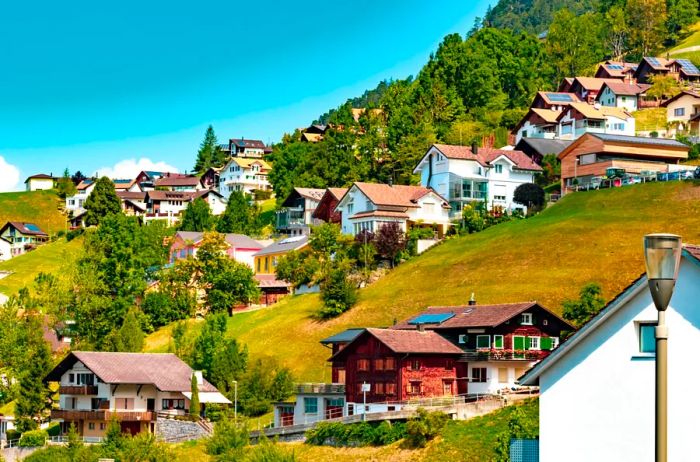
Photo by Ben Gingell/Shutterstock
At 6 a.m., the church bells of Triesenberg erupted in a cacophony. They didn’t ring six times or even sixty—the frenetic pealing continued for nearly ten minutes. Disoriented and weary, I stumbled to the window, peering out into a murky haze where only the outline of a church bell tower was discernible, wondering if the world was ending.
Later that morning, I navigated my way out of town through thick fog, the silence only interrupted by the gentle sounds of wind chimes and goat bells. Triesenberg was settled in the 1300s by the Walser migrants, whose legacy lingers in the ethereal forest: life-sized wooden carvings lurking among the trees, abandoned farming cabins clustered in solitary meadows. The rain wasn’t exactly falling; it was more like seeping; through the trees, I caught fleeting views of the valley as the fog stretched and swirled like cotton candy. By midmorning, I paused to explore the remnants of the Wildschloss, or “Wild Castle,” a 12th-century fortress that looms over the valley, before continuing my 2,100-foot descent to Vaduz Castle and the capital.
Although construction of Vaduz Castle started in the 13th century, the House of Liechtenstein didn’t take residence until the mid-20th century, after the Nazis annexed Austria, forcing them from their ancestral home in Vienna. The castle sits halfway up the mountainside, visible yet distant from Vaduz, and remains closed to the public. Visitors can glimpse it through an augmented reality tour on LIstory or wait until August 15, Liechtenstein National Day, when the reigning prince, Hans-Adam II, hosts the public for drinks in his royal rose gardens.
Down below, much of the 3.3-mile loop trail through Vaduz centers around the prince and his family. Highlights include the art museum, which houses a significant part of the royal family’s collection; St. Florin’s Cathedral, with its crypt containing several royal burials; and the Princely Vineyard, spanning 10 acres of pinot noir and chardonnay, complete with a fine dining restaurant and tasting room. Having spent three days in Vaduz before hitting the trail, I had already visited these attractions; now, as I descended from the castle, I felt a peculiar pride: I knew this city, I had walked its streets and ridden its buses. I was no longer merely a tourist—Ich bin ein Liechtensteiner! But with eight miles left to cover that day, I quickly navigated through the tidy streets, past ancient, weathered barns and green-shuttered stucco homes entwined in ivy, and plunged back into the woods.
By midafternoon, the sun finally broke through. The trail sharply ascended again, leading to a thousand-foot climb towards the village of Planken, but at some point, my app completely lost track of my location. After wandering for half an hour on a logging road due to a couple of missing signposts, I retraced my steps. The energy that had fueled my first 22 miles was waning—I was eager to reach Nendeln for the night, so I pushed on past the site of a failed Nazi coup in 1939, a ridge where Swiss troops had ambushed Habsburg forces in 1499, and a nunnery established by the Adorers of the Blood of Christ. According to the app, it was less than two miles to Nendeln, tantalizingly close enough to imagine the refreshing beer awaiting me at my hotel.
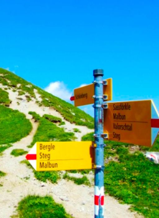
Photo by Mario Krpan/Shutterstock
In Planken, I was treated to some of the most breathtaking views of the entire trail. The sky was a delicate, milky blue, and the valley below, with its neatly arranged fields, stretched lush and green toward the river and the Swiss Alps beyond. However, days of rain had transformed the once winding paths into muddy torrents, washing away the flat stones that hikers relied on to cross the cascading streams. In spots where the slope dropped steeply to one side, ropes were strung between trees for support—but the ground was slippery, and more than once I found myself desperately reaching for the rope as my feet slid out from under me. At 23, I would have relished the thrill of it all, laughing as I splashed knee-deep into a challenging stream, proud of the mud splattered on my clothes and face, and the twigs tangled in my hair upon arriving in Nendeln 90 minutes later. At 53, I was just grateful to have made it down without injury and thankful for the hot shower waiting in my hotel room.
And then, of course, there was the beer.
Two years prior, in response to the rising popularity of e-bikes, Knöpfler and his team set out to create an alternative route that was bike-friendly. This involved adding new signage along the trail and updating the LIstory app. The revised route makes it easier for older or less fit hikers, as well as those pressed for time, to navigate. "But I believe you gain a richer experience when you walk it," Knöpfler confided.
With over 20 miles still to cover, I doubted I could finish in time, so on my final morning, I rented an e-bike in Eschen and sped out into the countryside. The skies remained overcast, but the air was warming up, and it was exhilarating to ride over the rolling hills of Güediga, where the medieval Counts of Vaduz had once executed criminals. However, after two long days of walking, I had established a rhythm, and as I cycled through the villages of Bendern and Ruggell, then into the peat bogs adorned with waving purple moor grass of the Ruggeller Riet, I longed for the leisurely pace of walking, allowing me to take in the landscape and reflect on it before moving on. I had to remind myself to slow down and take frequent breaks to fully absorb my surroundings.
Liechtensteiners refer to the northern region as the Unterland, owing to its relatively flat terrain. Much of the trail along the banks of the Rhine and eastward at the base of Schellenberg Hill takes advantage of this gentler landscape, allowing me to lower the e-bike's speed and enjoy the mild breeze and colorful flowers. However, as the steep ascent toward the Upper Castle began, climbing nearly 900 feet in just 2.5 miles, I switched to turbo mode, covering in 20 minutes what would have taken a grueling 90 minutes on foot.
The Upper Castle, erected in the 13th century by the Lords of Schellenberg, is undoubtedly the highlight of this final segment. It sprawls across a rugged hilltop, offering stunning views of the valley and Austria to the north. Easily accessible by car, I arrived to find a family picnicking by the entrance and a few tourists wandering the castle’s grounds, taking selfies—more people than I had encountered in three days. I felt a twinge of annoyance, as I had grown accustomed to the solitude. However, the weather had turned lovely, with wispy clouds drifting over the valley, so I settled on an 800-year-old stone wall, nibbled on my last energy bar, and turned off the app.
According to the United Nations World Tourism Organization, Liechtenstein ranks among the least-visited countries globally, attracting fewer than 80,000 visitors each year, and now I was one of them. I had traversed nearly the entire country from south to north, stopping at 147 points of interest (most of them, at least), and faced down rainstorms, mudslides, and buggy apps to reach this medieval fortress in Europe’s hidden heart. I was genuinely pleased that the journey hadn’t gone too smoothly—the challenges compelled me to rely on my instincts, make some errors, and navigate as I had in my 20s, before the era of GPS and smartphones. I had accomplished something meaningful, and while I looked forward to returning home to my family, a part of me was excited about discovering the next trail.
As the day began to wane, the last remnants of fog sparkled while drifting away from the mountains. I had one final descent ahead, with five miles remaining to reach my destination. So, when the wind picked up and the sun vanished behind a cloud, I jumped on the e-bike and embarked on a thrilling ride down to Mauren, followed by a smooth sprint to Schaanwald, leading to the almost deserted border post where the trail—and the country—concluded.


Evaluation :
5/5