12 Incredible Hikes in the U.S. Worth Planning a Trip Around
The U.S. offers an astonishing variety of terrains, making it one of the premier hiking destinations worldwide—whether you're seeking a secluded forest retreat or a thrilling climb along a mountain ridge. While many may know iconic trails like the Appalachian Trail and the Pacific Crest Trail, there are countless other breathtaking hikes of varying lengths traversing the country, from coast to coast.
These 12 trails reflect the stunning diversity of America's landscapes, offering not only epic adventures and challenges but also moments of tranquility and a deep connection to the natural beauty that characterizes the great outdoors of the United States.
Maah Daah Hey Trail
Located in North Dakota
- Distance: 144 miles
- Difficulty: Varies across different sections
In the Mandan and Hidatsa language, maah daah hey translates to “grandfather,” reflecting the Indigenous perspective of North Dakota’s often-ignored Badlands—a weathered, resilient landscape. The Maah Daah Hey Trail stretches 144 miles, showcasing some of the finest remnants of the nation’s majestic grasslands, alongside surprisingly rugged peaks, steep plateaus, and numerous river crossings. For those planning to hike the entire trail, it’s divided into eight segments with six access points and designated campsites about 20 miles apart. As you trek through Little Missouri National Grassland and both the North and South Units of Theodore Roosevelt National Park, you’ll encounter the serene company of pronghorns, bison, and bighorn sheep.
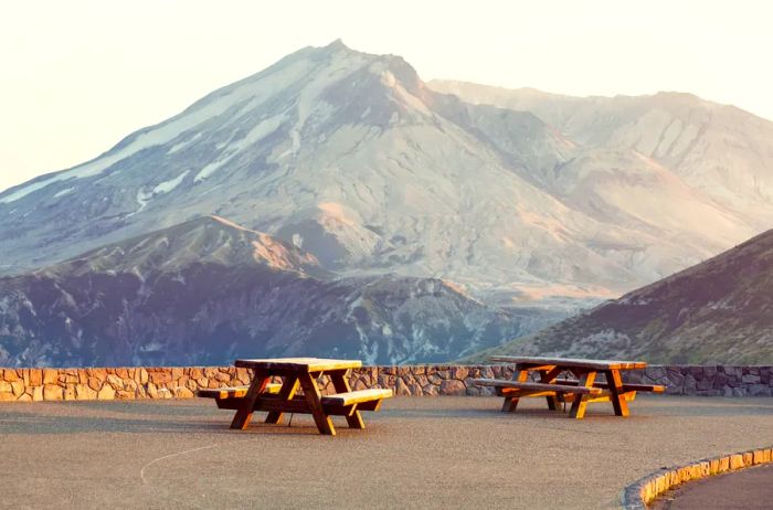
Photo by Galyna Andrushko/Shutterstock
Mount St. Helens
Washington
- Distance: 2–20 miles
- Difficulty: Ranges from moderate to challenging
The 1980 eruption of Mount St. Helens left an indelible mark on American history; more than forty years later, this Washington landmark remains the most active volcano in the contiguous United States, with occasional steam vents visible from the dome.
Hiking here is completely safe—and truly remarkable. Join the team at Mount St. Helens Institute, and within less than 10 miles, you can explore the blast zone, the crater, pumice plains, waterfalls, and even Crater Glacier, one of the fastest-growing glaciers globally. (If you wish to summit on your own, a permit is required.) Washington Trails Association provides a list of all currently accessible hiking trails; the shortest and easiest route is a 2.3-mile round-trip with a 100-foot elevation gain, while the longest and most strenuous hike, excluding summits, is the 20.2-mile Goat Creek Loop, which ascends 3,200 feet.
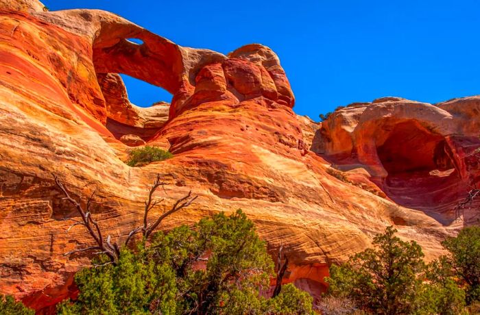
Photo by Gerald A. DeBoer/Shutterstock
Rattlesnake Arches
Colorado
- Distance: 15.5+ miles
- Difficulty: Challenging
In 2023, Arches National Park welcomed approximately 2.4 million visitors. In contrast, Colorado’s McInnis Canyons National Conservation Area, which boasts the second-highest density of natural arches in the nation, attracted around 300,000 guests. Reaching this remote area, known as Rattlesnake Arches, entails a rigorous 15.5-mile round-trip hike, plus additional miles for exploration within the canyon as you admire the sandstone formations from various perspectives. The iconic Rattlesnake Arch itself stretches 120 feet in height and 40 feet in width.
If you’d rather enjoy the stunning scenery among the arches and hoodoos (each uniquely shaped like a rattlesnake poised to strike), an off-road vehicle can navigate much of the route. Alternatively, you can let Adrenaline Driven Adventures handle the driving; they are the sole operator offering regular tours to this “hidden” gem.
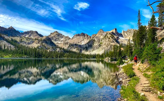
Photo by CSNafzger/Shutterstock
Alice-Toxaway Loop
Idaho
- Distance: 6–21 miles
- Difficulty: Ranges from moderate to challenging
Idaho's breathtaking Sawtooth Mountains offer views that can compete with the most stunning sights found in Glacier, Yosemite, or Grand Teton. While the Alice-Toxaway Loop is a well-known trail among the Sawtooths, it serves as a fantastic introduction to this rugged region, with several ways to experience it: hike to Alice Lake in just six miles, complete the entire loop at 21 miles, add a challenging 1,000-foot ascent to Edith Lake, or simply follow the shoreline of Toxaway.
No matter which route you choose, the trail is lined with Douglas fir and lodgepole pine, glistening alpine lakes, and the sharp peaks that give the Sawtooths their name. You’ll also catch a glimpse of Idaho’s own El Capitan, a formidable peak overlooking the Alice Lake Basin (distinct from the more renowned El Capitan in Yosemite).
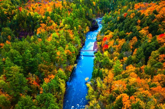
Photo by Big Joe/Shutterstock
North Country National Scenic Trail
North Dakota to Vermont
- Distance: 4,800 miles
- Difficulty: Ranges from easy to challenging
Stretching an impressive 4,800 miles—more than double the length of the Appalachian Trail—the North Country National Scenic Trail meanders through Vermont, New York, Pennsylvania, Ohio, Michigan, Wisconsin, Minnesota, and North Dakota. As the longest trail in the nation, it offers a journey from the flowing Great Plains through the lush forests of the Upper Midwest to the gentle mountains of New England.
You can choose to hike as much or as little as you desire. The approximately 200-mile segment that runs through northern Wisconsin is especially captivating, taking you from magnificent waterfalls (like those in Copper Falls State Park and Pattison State Park) to numerous lakes and the pine forests of Chequamegon-Nicolet National Forest.
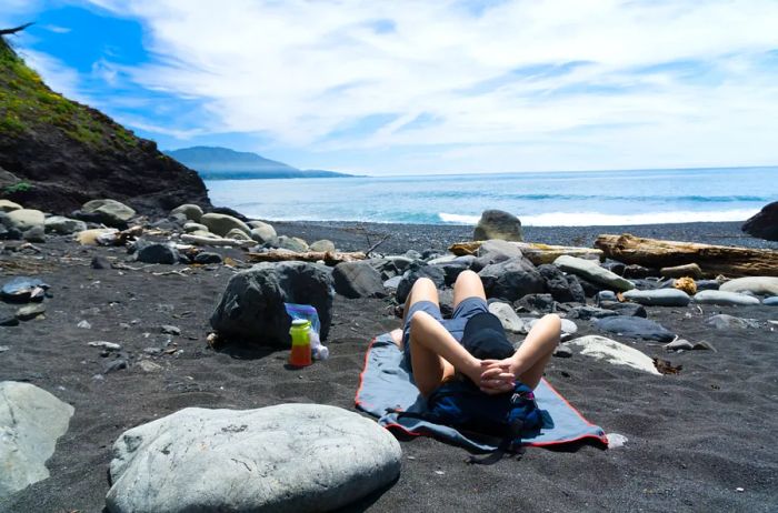
Photo by Geartooth Productions/Shutterstock
Lost Coast Trail
California
- Distance: 24.6–33.6 miles
- Difficulty: Ranges from easy to moderate
About 250 miles north of San Francisco, the Pacific Coast becomes too rugged for any development. Avoiding a fate marked by highways, it now offers some of the finest coastal hiking in the country, aptly named the Lost Coast.
The most popular section, from Mattole River to Black Sands Beach, spans 24.6 miles, typically enjoyed over three days. Due to the tides, you'll be encouraged to take your time and appreciate the waterfalls cascading into the ocean, the beaches along the cliffs, the surrounding forests and fog, as well as the sea lions, elephant seals, and otters playing nearby.
Note: A permit is required for this hike; they will be available starting October 1 for the following year.
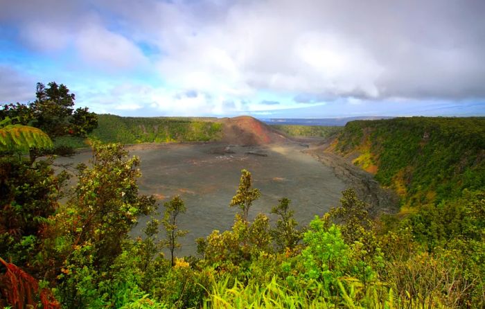
Photo by Marisa Estivill/Shutterstock
Kīlauea Iki Trail
Hawaii
- Distance: 3.2–6 miles
- Difficulty: Easy to moderate
Few hikes offer the chance to traverse a solidified lava lake, but the Kīlauea Iki Trail in the Big Island's Volcanoes National Park provides just that. The most straightforward path is 3.2 miles long, beginning with a swift descent through a vibrant rainforest that leads to a cairn-marked trail over the scorched Kīlauea crater. Alternatively, you can commence from the Devastation Trail, extending the hike to six miles, which includes scenic views from Uēaloha (Byron Ledge) and, if you choose, from within the Nāhuku Lava Tube.
Tip: Begin your hike early to beat the crowds and enjoy the stark beauty of the crater enveloped in morning mist.
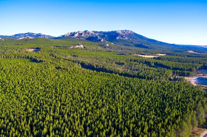
Photo by Jess Kraft/Shutterstock
Solitude Loop Trail
Wyoming
- Distance: 59.3 miles
- Difficulty: Challenging
Discover another hidden gem in Wyoming’s Bighorn Mountains, often overshadowed by the Yellowstone corridor. While many flock to the crowds, you can find solitude by exploring the Cloud Peak Wilderness on the Solitude Loop Trail, also known as trail #38. Experience glacier-carved valleys, serene lakes, and stunning vistas while sharing the trail with bears, moose, and elk.
Make sure to wear sturdy footwear and carry a reliable map—this 59.3-mile loop can be tricky to navigate and features an elevation gain of over 10,000 feet.
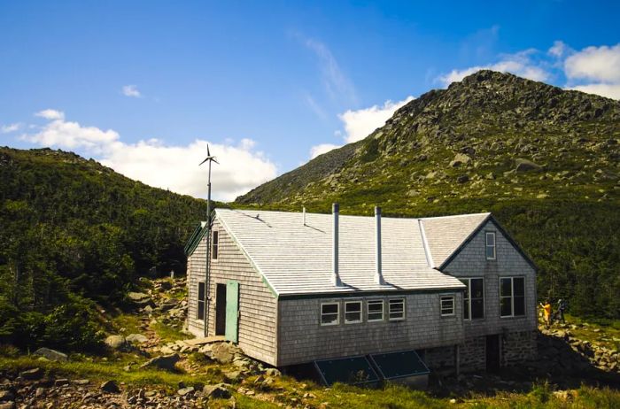
Photo by Ryan Garrett/Shutterstock
Presidential Traverse Trail
New Hampshire
- Distance: 18 miles
- Difficulty: Challenging
Conquer seven peaks, each named after a U.S. president, within just 18 miles on New Hampshire’s Presidential Traverse Trail. Though 6,288-foot Mount Washington may seem modest, this strenuous hike features an elevation gain of 9,000 feet and constant exposure, making it feel like a challenging 20-mile rock scramble. If you seek an unforgettable adventure in the Northeast, this is your trail. Many hikers prefer to complete this demanding route in two to three days, taking advantage of the Appalachian Mountain Club’s shuttle service and huts along the way for snacks, hydration, self-serve coffee, and moments to appreciate the scenery.
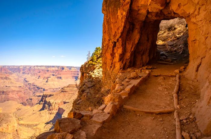
Photo by Kelly vanDellen/Shutterstock
Rim-to-Rim, Grand Canyon National Park
Arizona
- Distance: 23.9 miles
- Difficulty: Challenging
Few venture to hike from the rim to rim of the Grand Canyon, yet this experience transforms a busy national park into a tranquil (if sweat-inducing) journey. The adventure commences on the North Rim’s North Kaibab Trail, which descends 14.3 miles and 6,000 feet to the lush bottom of this UNESCO World Heritage Site, International DarkSky park, and one of the “Seven Natural Wonders of The World.”
Witness thousands of stars illuminate the night sky from Bright Angel campground, and in the morning, ascend from the banks of the Colorado River via the Bright Angel Trail, which climbs through two billion years of Earth’s history—4,500 feet and 9.6 miles—finally emerging on the South Rim with a sense of accomplishment.

Photo by David Lee/Flickr
Kalalau Trail
Hawaii
- Distance: 11 miles
- Difficulty: Challenging
Kauai’s Kalalau Trail is as perilous as it is stunning, stretching 11 miles along the renowned Nāpali Coast from Ke‘e Beach to the Kalalau Valley. While seasoned hikers can complete the round trip in a single day, many prefer to take up to three days to enjoy the swimming holes, admire waterfalls, and absorb the views of the hanging valleys and lush forests cascading into the ocean. However, don’t let the picturesque surroundings fool you: the trail is narrow, and water levels can rise suddenly.
You'll require an overnight permit to continue past mile two (Hanakāpīʻai Valley), even if you don't intend to camp. Permits can be obtained up to 90 days in advance.
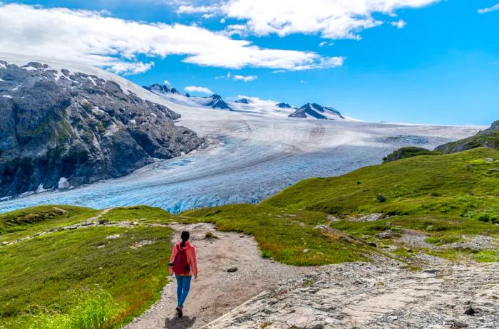
Photo by Jaime Espinosa/Shutterstock
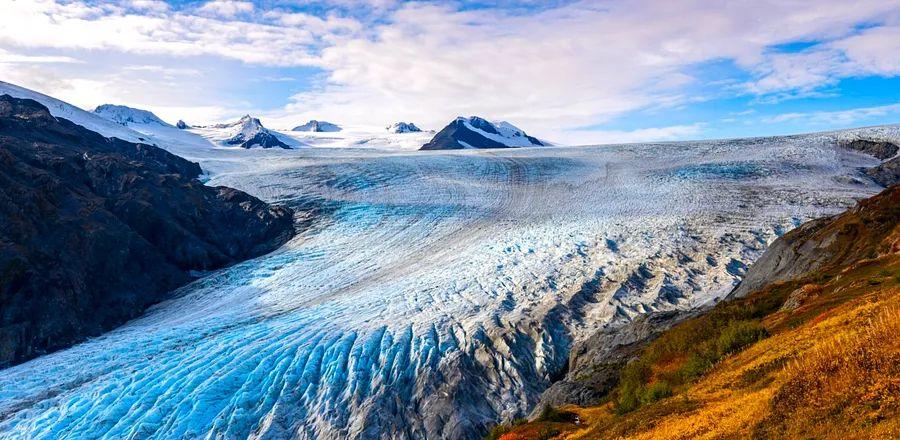
Harding Icefield Trail
Alaska
- Distance: 8.2 miles
- Difficulty: Challenging
Twenty years ago, you could get up close to Exit Glacier in Kenai Fjords National Park. By simply walking the one-mile glacier overlook trail, you could lean against, pick up, and touch the vibrant blue ice. However, since 2010, the glacier has retreated more than half a mile, making that same loop a place for distant photos. But if you venture off the loop onto the Harding Icefield Trail, a challenging 8.2-mile round trip, you can follow the glacier as it continues to pull back. You'll navigate through forests and meadows filled with heather, enjoying panoramic views of the entire icefield and even catching sight of nunataks, which are peaks that rise above the ice—future mountains for generations to come.
This article was first published in 2023 and most recently updated on October 9, 2024, with the latest information.

1

2

3

4

5
Evaluation :
5/5