Absolutely, You Can Now Trek the Appalachian Trail—in Ireland

Around 350 million years ago—long before dinosaurs roamed—much of Ireland resembled the Himalayas. All of Earth's continents had come together to create the supercontinent Pangea, with the immense Central Pangean Mountains rising near the equator. For roughly 100 million years, Ireland shared towering 20,000-foot peaks with Canada, Greenland, and Portugal, until the continents drifted apart. Despite the geological upheaval and the passage of time, these mountains still exist in the form of the Appalachians, the Scottish Highlands, and Ireland's dramatic sea cliffs.
In the mid-1990s, this geological connection inspired a cross-border vision for the Appalachian Trail, a nearly 2,200-mile footpath winding from Georgia to Maine. The first addition was Canada, featuring a 700-mile extension from Maine to Newfoundland's Crow Head on the Great Northern Peninsula. Then, in 2009, the International Appalachian Trail (IAT) made its way across the Atlantic.
"It was Scottish geologist Hugh Barron who proposed the idea," says Inga Bock, rural recreation officer with Donegal Local Development Company and a key figure in launching Ireland's section of the International Appalachian Trail. By 2010, routes were being envisioned by Ireland, Scotland, Greenland, and Norway; since then, IAT chapters have emerged across the ancient mountain range, reaching from England and Wales to Portugal and Morocco.
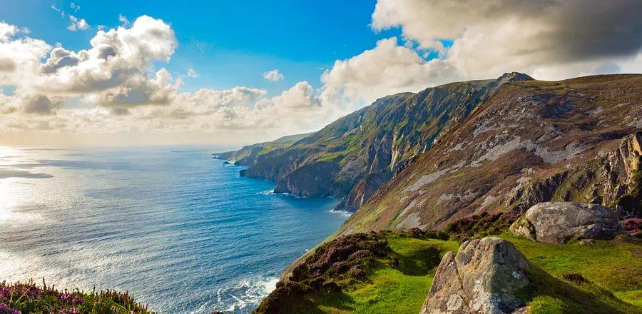
Ireland takes its carboniferous legacy seriously: Established in 2013, the 279-mile Ulster-Ireland Route—the Irish segment of the IAT—transcends a mere map thanks to over $1.5 million in funding from action groups and collaborative efforts between Northern Ireland and the Republic of Ireland. In 2021, the route underwent a significant upgrade. "While the trail was navigable in 2013, it included long stretches on back roads, muddy off-road sections, and lacked continuous signage," Bock explains. Today's hikers will discover consistent green-and-yellow branding, improved treadways, expanded off-road segments, and new amenities. Starting on Ireland's west coast at Sliabh Liag, Europe’s highest sea cliffs, the trail winds through the Bluestack Mountains and into Northern Ireland; follows the volcanic Giant’s Causeway along the northern coastline; and concludes on the east coast in Larne, just south of the Glens of Antrim.
Iain Miller, a trekking and climbing guide for Unique Ascent, a guiding company located in County Donegal, Ireland, highlights the diverse vistas hikers encounter on their journey: “The dramatic landscapes vary greatly between the two seascapes at either end of the trail,” he notes. The west coast features crashing waves and tumultuous seas, while the east coast offers more tranquil waters with popular beaches for swimming. Aside from well-known sites like Sliabh Liag and the Giant’s Causeway, Miller mentions that “it’s quite likely you’ll find solitude along the way. The IAT isn’t crowded as an independent trail.” (Exact hiker numbers remain unclear.)
Although Miller often explores the blanket-bog uplands of the Bluestack Mountains, he concentrates his IAT tours on the sea stacks and secluded cliffs of County Donegal, close to the trail’s beginning near An Port. “This is an astonishingly beautiful bay situated in one of the most isolated areas of mainland Ireland. It serves as the entry point to Ireland’s final wilderness,” he explains. Most travelers should consider hiring a guide like Miller—due to environmental regulations, the trail at Sliabh Liag is the only unmarked section, and only experienced hikers should navigate it without assistance.
Beyond Sliabh Liag, Miller and Bock suggest several spots for aspiring hikers: The Glencolmcille region of the trail—about seven miles from Sliabh Liag—offers stunning views, from towering headlands to the horseshoe-shaped Strand Beach, which overlooks the North Atlantic. About thirty-five miles west, hikers will discover Lough Eske, where picturesque lake scenery surrounds two luxury hotels, one being Lough Eske Castle. Across the border in Northern Ireland, the North Antrim Cliff Path, an 8-mile segment of the larger 18-mile Causeway Coast, links Dunseverick Castle to the famous Giant’s Causeway.
Bock advises eager hikers to visit the IAT Ulster-Ireland website for day planning and accommodation bookings. Walking services—which include guided tours as well as luggage and shuttle transfers—are also available, though Bock recommends hikers first check if their lodging provides this support, as many do. The website features a trail map, highlights day hikes, and offers contact details for various regional visitor centers that can address inquiries and assist hikers in creating itineraries.
Miller shares some final advice for those contemplating the Ulster-Ireland Route of the IAT: Carry a paper map, since phone reception and Wi-Fi can be unreliable; secure your accommodations early, particularly during the summer months; and make use of your lodge’s drying room—after all, Ireland is accustomed to unexpected rain showers.
Regardless of the weather, the trail provides hikers with a uniquely rare opportunity: a clearly marked path free from crowds. “I cover many trails,” Bock remarks, “but the IAT is truly exceptional.”
Evaluation :
5/5


