A summer without El Niño is approaching. Here's what that could mean for the U.S.

Spring is here, but it’s never too early to start thinking about summer weather—especially with El Niño, which contributed to last year’s intense summer, quickly fading and expected to vanish before the season fully begins.
El Niño's disappearance doesn’t mean we’re free from the heat. With global temperatures rising due to human-caused climate change, some forecasters predict this could make things even hotter.
What to expect from this summer’s weather
El Niño is a natural climate phenomenon marked by warmer-than-usual sea surface temperatures in the central and eastern Pacific. When the water cools, it triggers a La Niña event. Both phases can significantly influence global weather patterns.
By June, experts expect ocean temperatures to return to near-normal levels, signaling a neutral phase before La Niña strengthens in early summer, according to NOAA’s Climate Prediction Center.
However, the impact of El Niño or La Niña on U.S. weather is not consistent and can vary significantly depending on the strength of the phenomenon and the time of year.
The effects of El Niño or La Niña on U.S. weather are more complex in summer than in winter, particularly during transitions between the two phases, explained Michelle L’Heureux, a climate scientist at the Climate Prediction Center.
During winter, temperature differences between the tropics and North America are much more pronounced, L’Heureux noted. This allows the jet stream to become stronger and more influential, guiding storms more predictably across certain regions of the U.S.
In summer, the temperature gap between the two regions is less extreme, reducing the direct impact on U.S. weather.
We can look to past summers with similar conditions to get an idea of what might unfold this summer.
To put it simply: It’s going to be hot.
The summer of 2016 was one of the hottest on record for the Lower 48. By midsummer, La Niña conditions took hold, following a powerful El Niño winter.
Summer 2020 followed a similar pattern: La Niña emerged midseason after a mild El Niño winter, yet it still delivered one of the hottest summers on record and the most active hurricane season ever.
On top of that, these climate events are unfolding in a rapidly warming world, increasing the likelihood of even more extreme heat.
As L’Heureux pointed out, 'This isn’t like our grandmother’s El Niño transition – we’re in a much warmer world now, so the effects will be different. We’re already seeing the impacts of climate change.'
The current summer temperature forecasts for the U.S. are definitely pointing to intense heat.
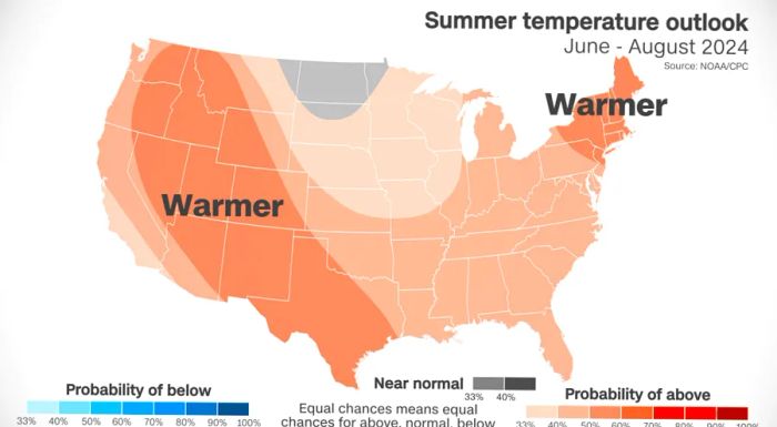
Above-average temperatures are expected to dominate almost every part of the Lower 48. Only parts of the Dakotas, Minnesota, and Montana will have an equal chance of experiencing near-normal, above-normal, or below-normal temperatures.
A large part of the West is expected to experience warmer-than-normal conditions. This forecast aligns with long-term climate trends, according to L’Heureux.
Summers in the West have warmed more than in any other U.S. region since the early 1990s, according to NOAA data. Phoenix is a prime example: last July, the city's average temperature reached a staggering 102.7°F, making it the hottest month on record for any U.S. city. It also marked the deadliest year for heat in Maricopa County, where Phoenix is located.
Forecasts also indicate a troubling precipitation trend for certain areas in the West.
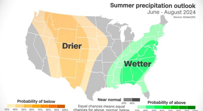
Large parts of the West and central U.S. are expected to be drier than usual. This combination of dryness and above-average heat, which exacerbates the dry conditions, could lead to new or worsening droughts.
Forecasts show wetter-than-usual conditions from the Gulf Coast to the Northeast. The East could see stormy weather throughout the summer, though it’s unclear whether it will come from typical thunderstorms or tropical systems.
A scorching summer is also anticipated in the oceans.
Heat isn’t the only hazard to watch for.
Strengthening La Niña conditions, combined with ocean temperatures that have been at record highs for over a year, could significantly intensify the Atlantic hurricane season.
A warming planet provides more fuel for tropical storms, leading to more intense and stronger storms. La Niña often creates atmospheric conditions that favor storm development and their persistence in the Atlantic.
Earlier this month, forecasters at Colorado State University released their most active initial hurricane forecast to date.
The group stated in a news release, 'We expect a significantly higher likelihood of major hurricanes making landfall along the U.S. East Coast and the Caribbean this season.'

1

2

3

4

5
Evaluation :
5/5